Saturday September 7th I took advantage of some solo time (My wife was in all-day dog-training class) to hike / Climb Mt. Angeles. The destination was a suggestion from my coworker Rob. I arrived at the park at 10 AM and checked my planned route with the rangers at the entrance station. The super helpful ranger there agreed that my plan was the best route up (STAY LEFT, more on that later…), and I proceeded up the winding road through the fog to the Hurricane Ridge visitor center.
As soon as I got above the fog I was greeted by this amazing view:


It was my first visit to Hurricane Ridge, so I took a few moments to take in the view from the visitor center. In retrospect I should have moved a bit faster, as better views were to be had soon enough, but I’m happy with how the trip turned out overall. Here’s the pano:

Then I hit the trail. This one starts off right with a bunch of switchbacks just to get to the local lookout, lots of “non hikers” around here, as it’s paved, and super accessible for most, including differently abled or elderly folks, though it is a bit of a workout. Once you clear the first lookout though, it’s typical trail, if a bit busier than most.
The trail runs up and down along the south side of the ridge, gaining and losing elevation a few times. Keep an eye out for Marmots in the golden fields in this first section.


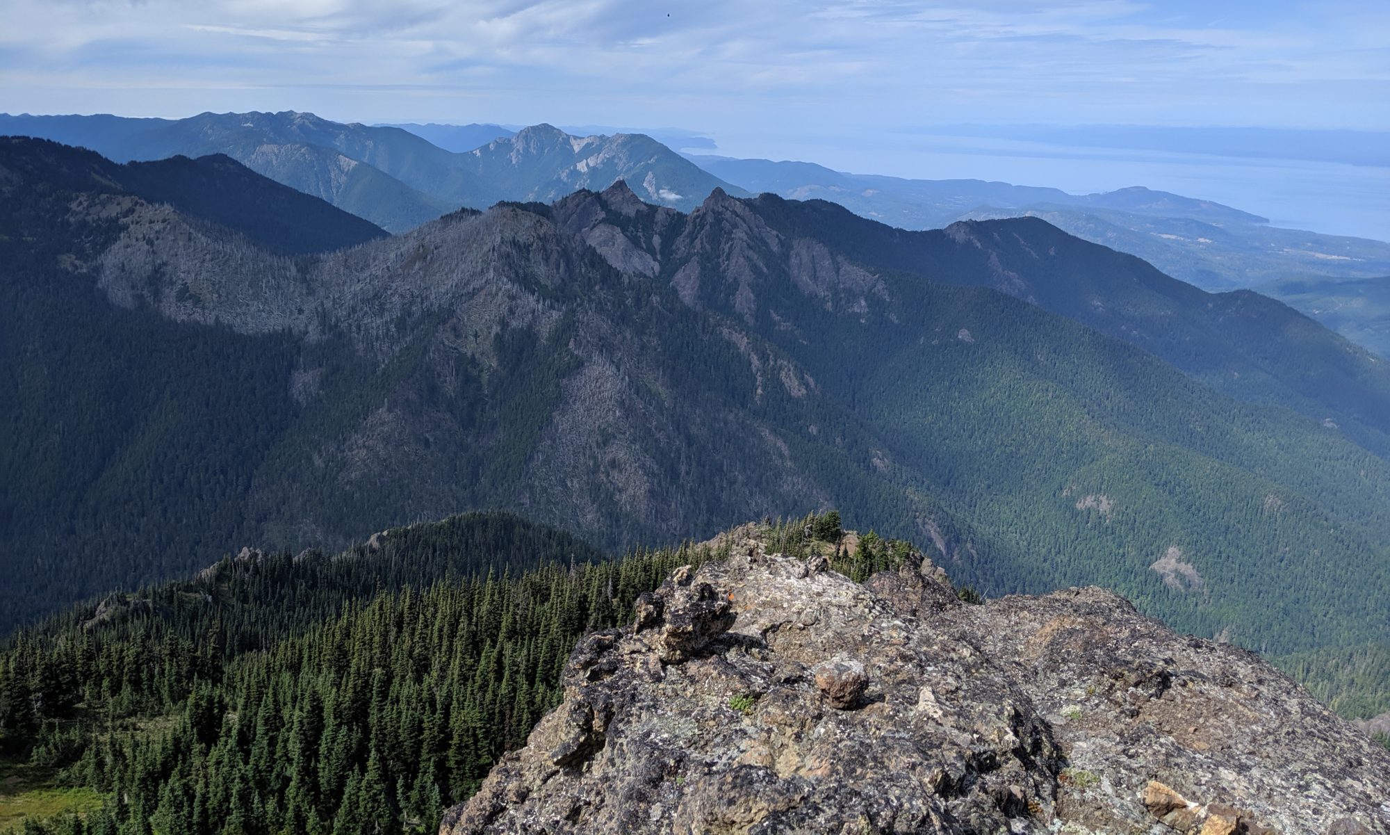
There is one major valley to cross, with quite a bit of elevation gain and loss before you get to the Mt. Angeles summit social trail. My first good view of Angeles came from across this valley, included with a couple of other closer shots from later on:
I continued down the valley and across it, I took the wrong trail down and basically slid/scrambled my way down, realizing on my way back I had missed the right trail by about 10 ft. LOL!
I continued on through the valley (which felt quite short on the way in) to the point where the social trail for the summit split off. I took off, basically straight up the side of the mountain. WHO NEEDS SWITCHBACKS? Let’s just go straight up. 😀
As mentioned, as soon you break away it’s straight up the side of the mountain, no switchbacks. It’s almost steep enough to use hands, but at this point not yet beneficial. After this initial push you’re greeted by a beautiful alpine meadow with cross-sound views of Victoria:


A bit more climbing was next and this time hands were totally required as you scramble up a large boulder and around a couple more. After this second section of scrambling there are some nice views of the summit, and rest of the olympics.
A little more steep scrambling brought me to some trees and an option to go “Up” or “Left”. I chose “Left” since every trail report, person I’ve talked to, etc, said “Stay left”.
Turns out I should have gone “Up” here (“stay left” meant stay left of the big scree field behind me in the above 360 shot)
But, I stayed left. And that meant crossing a bit of a rockslide field, and over a rock wall into a gulch. there was no more “going left” at this point, so I decided up the gulch it was.
And it was STEEP! Rockslide chute in the middle, with plants on either side and interspersed through the middle, plenty of hand and footholds, though not much of a “trail”. By this time I had decided that i was decidedly off of “the route”, but was having fun. It was around this time I got a message on my Garmin inReach saying my partner was going to be ready 30 minutes early. (ASIDE: The inreach, is an awesome little bit of kit. keeps you in touch when satellite is the only means, highly recommend.) It was about that time I made the decision to end my attempt and turn back, or I would have no time for any lunch, which was starting to feel the need for.
After the short climb back down this gully I realized the rock wall I had climbed over was a little tougher to get back to the other side of. I had to beach myself on my belly up on it to get up, and my right foot was a bit loose. Not my favorite moment of the climb, but would not have been fatal if it went south.
Once back on the rock wall I carefully made my way down the ridge of it to a flat spot with a nice vantage point. This is where I had lunch:
The views from this spot were amazing.


The friends and lichens were awesome as well:


Once I finished lunch I climbed back up the rock spine and back across the slide area to the trail. Then slid/climbed the rest of the way back to the main trail 🤣.
The rest of the hike was uneventful, except for some minor cramping on the way back because I was low on water, and this cute, but distant marmot:

And this chipmunk:

Got back to the trailhead, washed up and headed to our Airbnb.