This week’s adventure email just went out! if you missed it you can check the details here.
And SIGN UP so you never miss an adventure!
Adventures, professional musings, whatever else I can think of.
This week’s adventure email just went out! if you missed it you can check the details here.
And SIGN UP so you never miss an adventure!
Saturday September 7th I took advantage of some solo time (My wife was in all-day dog-training class) to hike / Climb Mt. Angeles. The destination was a suggestion from my coworker Rob. I arrived at the park at 10 AM and checked my planned route with the rangers at the entrance station. The super helpful ranger there agreed that my plan was the best route up (STAY LEFT, more on that later…), and I proceeded up the winding road through the fog to the Hurricane Ridge visitor center.
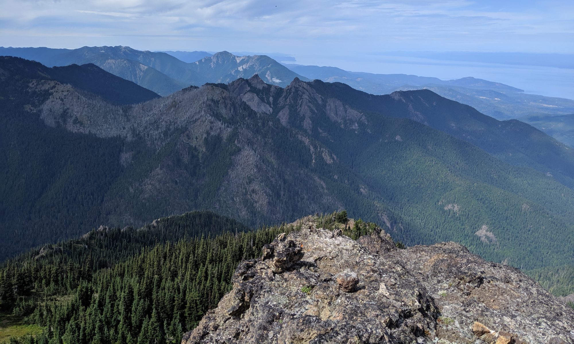
As soon as I got above the fog I was greeted by this amazing view:


It was my first visit to Hurricane Ridge, so I took a few moments to take in the view from the visitor center. In retrospect I should have moved a bit faster, as better views were to be had soon enough, but I’m happy with how the trip turned out overall. Here’s the pano:

Then I hit the trail. This one starts off right with a bunch of switchbacks just to get to the local lookout, lots of “non hikers” around here, as it’s paved, and super accessible for most, including differently abled or elderly folks, though it is a bit of a workout. Once you clear the first lookout though, it’s typical trail, if a bit busier than most.
The trail runs up and down along the south side of the ridge, gaining and losing elevation a few times. Keep an eye out for Marmots in the golden fields in this first section.


There is one major valley to cross, with quite a bit of elevation gain and loss before you get to the Mt. Angeles summit social trail. My first good view of Angeles came from across this valley, included with a couple of other closer shots from later on:
I continued down the valley and across it, I took the wrong trail down and basically slid/scrambled my way down, realizing on my way back I had missed the right trail by about 10 ft. LOL!
I continued on through the valley (which felt quite short on the way in) to the point where the social trail for the summit split off. I took off, basically straight up the side of the mountain. WHO NEEDS SWITCHBACKS? Let’s just go straight up. 😀
As mentioned, as soon you break away it’s straight up the side of the mountain, no switchbacks. It’s almost steep enough to use hands, but at this point not yet beneficial. After this initial push you’re greeted by a beautiful alpine meadow with cross-sound views of Victoria:


A bit more climbing was next and this time hands were totally required as you scramble up a large boulder and around a couple more. After this second section of scrambling there are some nice views of the summit, and rest of the olympics.
A little more steep scrambling brought me to some trees and an option to go “Up” or “Left”. I chose “Left” since every trail report, person I’ve talked to, etc, said “Stay left”.
Turns out I should have gone “Up” here (“stay left” meant stay left of the big scree field behind me in the above 360 shot)
But, I stayed left. And that meant crossing a bit of a rockslide field, and over a rock wall into a gulch. there was no more “going left” at this point, so I decided up the gulch it was.
And it was STEEP! Rockslide chute in the middle, with plants on either side and interspersed through the middle, plenty of hand and footholds, though not much of a “trail”. By this time I had decided that i was decidedly off of “the route”, but was having fun. It was around this time I got a message on my Garmin inReach saying my partner was going to be ready 30 minutes early. (ASIDE: The inreach, is an awesome little bit of kit. keeps you in touch when satellite is the only means, highly recommend.) It was about that time I made the decision to end my attempt and turn back, or I would have no time for any lunch, which was starting to feel the need for.
After the short climb back down this gully I realized the rock wall I had climbed over was a little tougher to get back to the other side of. I had to beach myself on my belly up on it to get up, and my right foot was a bit loose. Not my favorite moment of the climb, but would not have been fatal if it went south.
Once back on the rock wall I carefully made my way down the ridge of it to a flat spot with a nice vantage point. This is where I had lunch:
The views from this spot were amazing.


The friends and lichens were awesome as well:


Once I finished lunch I climbed back up the rock spine and back across the slide area to the trail. Then slid/climbed the rest of the way back to the main trail 🤣.
The rest of the hike was uneventful, except for some minor cramping on the way back because I was low on water, and this cute, but distant marmot:

And this chipmunk:

Got back to the trailhead, washed up and headed to our Airbnb.
On the first day of September my partner Cindi and I geared up, grabbed the doggo, and headed for the Franklin Falls trailhead with the intent of seeing how far up the Denny Creek trail we could get.
We got a (I thought) fairly early start out of the house, but had farther to drive, so we didn’t arrive until close to 11. Just in the nick of time too, as the parking was filling up fast. A note to be aware of: The Denny Creek trailhead itself is closed, but luckily starting from the Franklin Falls Trailhead is only about an additional 500m. No biggie. That said, the parking at the Franklin Falls trailhead is a little tight because of this, so I advise arriving a little earlier than we did.
We hit the restroom and headed across the bridge towards the Denny Creek trailhead. Stopped there to send a hike plan to my mom with details on where we were and when we’d be checking in. While waiting for the text to go through we stretched. Both of these are critical pre-hike activities.


The lower part of the Denny Creek trail is not steep, a jaunt through the forest under (fairly noisy) I-90. It’s beautiful and a great start, if you can ignore the freeway noise.

It felt like almost instantly that we arrived at the Denny Slabs/Slides. Large granite formations that result natural “water slides” or just a lovely place for a family picnic. Of course any stone that is wet is slick, and that holds true here, witnessed many slips in the 20 minutes we hung out there, all resulting in only bruised butts or pride.


We found the trail marked with a small “trail” sign on the other side of the lower part of the slabs and continued up. After the slabs the trail gets a little tougher, with alternating sections of talus, and forested switchbacks. There has recently been work by the WTA on this section of the trail clearing brush for a much wider trail. While a workout, the trail is fairly easy, if rocky.


At one point in the middle of a section of talus we came across the gurgle of an underground stream beneath us in the rocks. Audible only for a moment as you pass over. Quite peaceful:
Not far from there we came out of some trees and got our first view of Keekwulee falls:

We saw the turnoff for the falls but decided to keep going up to see what else was up there. In the switchbacks above Keekwulee there are a couple of pretty intense exposures off of the end of the switchbacks. Luckily most are marked with a barrier of some sort, but this view gives a good idea of the drop off:

wide paths though, so not a huge risk, but something to know if you ever chose to run the trail.
We kept going up until we crossed denny creek the last time before the pass. At this point we were crossing some very old, and in need of repair, footbridges through the bottom of the valley. It was at this point we decided to turn around (I was getting hangry, Poppy needed a rest) and go back to the rock/sand bar in the middle of the creek for a quick snack, then make our way back to the falls for a proper lunch.


Quick snack had for everyone, including Miss Poppers. We continued back down the switchbacks, stopping only to take in the breeze flowing up the cliffs at the turns near the stream valley.

Finally we arrived at the turnoff for the falls, noticing a small, half-toppled cairn. Cindi left a piece of quartz she’d been carrying since the stream break at it.
When we climbed down towards the upper falls there were a few kids there, egging each other on to be brave enough to swim in the pool (which looked FRIGID). Two boys and two girls, probably late H.S. or early college age. The boys finally took the plunge, looking pretty shocked, but ok. They posed for some pics, and then got out.

Meanwhile we walked down towards the edge of the larger, lower falls to explore a bit.


Having gone as far as we were comfortable with the dog, we headed back up to the upper falls pool to set up a little lunch spot. By then the kids had moved on and we had a moment to ourselves with the upper falls, the blanket, and some ramen.
Before we got into lunch, though, I had to brave the pool myself, so I stripped down to my shorts and jumped in. A few seconds was plenty. Probably not much more than 32 degrees if I had to bet. Way colder than the sound.
After the dip I was ready for some hot coffee and ramen so I fired up the Jetboil and got to cooking.


I didn’t have my water filter yet, so we were limited to the water we brought, silly move. I went out and bought a Sawyer immediately after this trip. Live and learn.
Before we left I took this 360 shot:
And I had to hop up on top of the falls to get this shot looking down:
On the way out, we noticed that someone had re-built the cairn marking the falls trail, and placed Cindi’s quartz at the top of the cairn. Cindi was naturally delighted.
As we rounded the bend on our way out, I took this last parting shot of the falls:
As per the usual, the hike down was fairly uneventful, and the doggo was asleep as soon as we got to the car (maybe even the last 500m in mom’s arms). On to the next adventure!
On Saturday August 24th My partner Cindi, our dog Poppy and I geared up and headed for Tiger Mt. #3 summit. Here is a link to the WTA page.

This was our first time up this trail and we were not quite prepared for the immediate (and intense) switchbacks in the first mile. We were both feeling it so we decided to take the “less intense” option at break right at the Talus Rock trail intersection. LOL.
It was beautiful, but no less intense.


Ok cool, big rocks. Lots of up and down but to be honest it did give us a chance to catch our breath a bit. We encountered another hiker moving fast in the opposite direction and said hi.
5 minutes later that hiker comes up behind us while we navigated a steep decline, and asks:
“Hey is this the section line trail?”
“No it’s talus rocks”
“Ah I think I took a wrong turn.”
So we figured it out and yes, he had continued right onto talus rocks missing the section line start (which is about half way up the mountain). we sent him on his (now correct) way to section line, following behind. Turns out him missing the trail was a sign.
We get to section line and it’s clearly marked, but with a sign that says “unmaintained trail.”
Well, we’re here… I offer to turn back. Cindi is undeterred, so we press on.


Section line is mostly forested, straight up the side. Few switchbacks, just a lot of high grade forest floor. A few rock encounters, and maybe some slight scrambling.
Part way up we encountered a brief section of railroad grade, but quickly cross it and return to the hill climb
By the way poppy is living her best, “pulling” me up the hill.
Ultimately section line isn’t really too tough. A few spots where it’s a little unclear where to go, but by no means are you off trail. That said, by the end you are worn, and the last few hundred meters before you come out on the cable line trail are brutal. Once you get there however it’s a quick jaunt to the summit and a sunny rock bench.
We found a secluded spot just 5m from the summit to hang the hammock, chill and make some coffee. A couple of grey jays found us and I swear they wanted to be friends. One even followed me to pee… I turned my head to see him fly away from where he had been: 20cm from my face.


We took the actual tiger mountain #3 trail back down. The way back down wasn’t particularly eventful, but there were some great views, and interesting sights. The trail is much better though. Wide, well maintained, and little trash.


All in all we had an awesome day, and everyone was thoroughly tired when we finished. Poppy was asleep before we left the trailhead.

I’m tired of posting things on insta/fb/twitter etc etc, and not being able to tell fun stories in a multi-media format, so here it is, a good 30 years after blogs were “a thing” and at least 15 years after I first built this website, I’m actually attempting to do something with it.
So there it is. Welcome to my Blog.